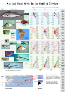
Students Use GloBI Data to Visualize Spatial Food Webs in Gulf of Mexico
As part of the Information Visualization MOOC (Massive Open Online Course) led by Dr. Katy Börner of Indiana University, students Twy Bethard (United States), Andrew Miles (United Kingdom), Edward Kok (Netherlands), and Mattia Della Libera (Italy) used GloBI data to create an insightful visualization of spatial marine food webs in the Gulf of Mexico. The full PDF version of the visualization can be found here. Jim Simons, GloBI datasets contributor and lead for GoMexSI, provided an early version of the normalized GloBI data to Twy Bethard in an easy-to-use CSV file format.
If you are interested in getting access to a massive amount of global species-interaction data, please visit our EOL GloBI Data wiki or contact us through this blog.


